Atlanta’s biggest snowfall events of all time are listed in the table below. The most snow ever recorded on a single day in Atlanta was on January 23, 1940 when 8.3 inches fell. The top 10 snowstorms in Atlanta have a median accumulation of 4.2 inches.
We often hear the cliche:
“…accumulation is not expected because the ground is too warm…“
The problem with that statement is that it is nothing more than hand-waving, with no consideration of the microphysical processes associated with snow or sleet melting on exposed surfaces, including pavement, particularly if temperatures during the event fall into the 20s. Melting snow or sleet causes the surface temperature to drop rapidly, especially if the precipitation is heavy. For example, if you take an ice cube out of the freezer and place it on your kitchen counter at room temperature, the temperature of the counter beneath the melting ice will drop rapidly. It is my goal to eradicate this myth, because some of the most significant snow/sleet storms that caught people by surprise are those that were preceded by warm temperatures and some forecasters told the public that there would be no accumulation.
Sufficient conditions for snow or sleet to accumulate:
- The temperature of surfaces upon which the precipitation falls must be subfreezing;
- If surfaces are above freezing, the precipitation rate must exceed the melt rate;
- Melting snow/sleet can cause the temperature of surface to drop rapidly due to the latent heat of melting (very efficient)
What about freezing rain?
This discussion is about the efficiency of snow and sleet to cool the ground due to the latent heat of melting. Rain is less efficient at cooling surfaces than snow or sleet, because the latent heat of melting is absent; furthermore, the freezing of water releases latent heat which can cause a sensible increase in air temperature (i.e., freezing rain is a self-limiting process). If raindrops are super-cooled, they can certainly cause surface temperatures to drop; oftentimes rain drops are not super-cooled because they have passed through a deep warm layer aloft.
Duration of warm spell?
Preliminary results find NO correlation between the capacity for snow/sleet accumulation following a warm period and the duration of the warm period itself. The same result is achieved irrespective of duration, whether the warm period was a month or just a week; the critical factors are the surface temperature, the specific heat capacity of various surface materials, and the other factors listed above.
✏️ Tidbit: Officially, Atlanta’s “worst” snowfall on record was 8.3 inches on January 23, 1940. The second greatest snowfall accumulation was 7.9 inches during the “surprise” snowstorm of March 24, 1983. Incidentally the day before the March 24, 1983 snowstorm, the high was 61º and the day of the snowstorm itself, the high was 47º (just two hours before the snow began).
This simple study examines the temperatures for the 21 days prior to each of the top-20 greatest snowstorms on record in Atlanta, Georgia. On the graph below, the snowstorm occurred on “day 22”.
List of the top-20 snowstorms (and sleet) for Atlanta (1928 to present)
Date Rank Accumulation Median High Temp for
the Preceding 5 DaysHigh Temp the Day
Prior to the EventHigh Temp the Day
of the Event
01/23/1940 1 8.3" 35ºF 35ºF 36ºF
03/24/1983 2 7.9" 52ºF 52ºF 47ºF
01/30/1936 3 6.0" 33ºF 33ºF 32ºF
01/18/1992 4 5.0" 49ºF 37ºF 43ºF
01/07/1988 5 4.2" (sleet) 41ºF 38ºF 32ºF
03/13/1993 6 4.2" (Blizzard of '93) 70ºF 55ºF 38ºF
03/01/2009 7 4.2" 61ºF 61ºF 52ºF
01/12/1982 8 4.0" (Snow Jam '82) 47ºF 24ºF 26ºF
02/18/1979 9 4.0" (sleet) 62ºF 62ºF 28ºF
02/10/1934 10 4.0" 56ºF 62ºF 23ºF
03/11/1960 11 4.0" 40ºF 40ºF 41ºF
02/26/1952 12 3.9" 53ºF 45ºF 48ºF
03/02/1942 13 3.7" 40ºF 47ºF 43ºF
01/09/2011 14 3.7" 49ºF 59ºF 34ºF
01/22/1987 15 3.6" 43ºF 40ºF 37ºF
02/12/2010 16 3.6" 47ºF 36ºF 38ºF
01/09/1962 17 3.5" 60ºF 41ºF 41ºF
02/15/1958 18 2.7" 38ºF 48ºF 42ºF
03/02/1980 19 2.7" 61ºF 50ºF 27ºF
01/28/2014 20 2.6" 49ºF 61ºF 30ºF
High temperatures prior to each of the top-20 snow storms
The snowstorm occurs on “day 22” in the chart
In this study, the top-20 snowstorms in Atlanta’s historical record dating back to 1928 are considered. The chart below shows the trend of daily high temperatures for the 21 days prior to each of the top snowstorms. The 20 snowstorms multiplied by 21 days yields 420 days. Of those 420 days, only 15 days (3.5%) had a high temperature below freezing.
Displayed on the graph are:
- The high temperatures for the 21 days leading up to the snowstorm;
- The high temperature on the day of the snowstorm (day 22);
- The high temperature on the day following the snowstorm (day 23)
Mouse over the dots in the lower right hand corner to see the snowfall amounts.
Average daily temperatures (average of the high and low)
Snow-Jam ’14 Ranks #20 and Certainly Proves My Point
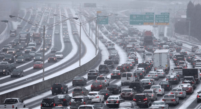
On January 29, 2014, Atlanta and Birmingham were brought to a standstill for days. People were trapped in their cars on virtually every highway and interstate for 24 to 48 hours. I wasn’t at all surprised ahead of the storm to hear the phrase that makes my skin crawl, “we don’t expect significant accumulation because it has been … eh hem… warm in recent days.” The temperature on the day before the snowfall was in the lower 60s (officially 61º at Hartsfield). The median high temperature for the 5 days prior to the snow event was 50º. This photo sums it up.

❄️ Be prepared this winter. Make sure you and your family know about the various winter weather advisory types and the criteria used for their issuance. As always, beware of internet hype and weather hoaxes.
