Data Update Cycle: The 1-hr mosaic is updated every 5 min (approx). All other mosaics are now updated hourly, including the 48h and 72h maps. This schedule replaces the previous update cycle, which limited hourly updates to the 3h, 6h, 12h, and 24h mosaics, while 48h and 72h maps were generated once daily.
Showing the rainfall map for the past
Click anywhere on the map for a rainfall estimate.
Displayed: Precip for the past 72hrs
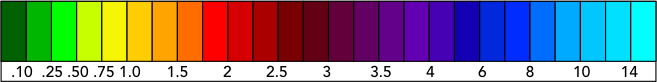
Data collected using Doppler radar polarimeteric technology are objectively analyzed by complex precipitation algorithms to produce very accurate estimates of accumulated precipitation at each grid point.
Our maps will display on any mobile device, including smartphones and tablets, though you may notice a better visual presentation and optimal performance from a desktop computer.