Skip to content
iWeatherNet
  • DFW Weather
    • Forecast
    • Current Conditions at DFW
    • Texas Wind Chill Map
    • Sortable Currents in N. TX
    • DFW Doppler Radar
    • Dallas Live Cam
  • Atlanta Weather
    • Forecast
    • Current Conditions in Atlanta
    • Georgia Wind Chill Map
    • Sortable Currents in Georgia
    • Atlanta Doppler Radar
    • Closings Due to Weather
  • Radar
    • Future Radar
    • Site-Specific Doppler
    • Severe Weather Browser
    • Total Rainfall (Radar Estimated)
  • Satellite
    • 7-Day Composite Satellite Loop
    • 3-Day Infrared Satellite Loop
    • 3-Day Water Vapor Loop (Color)
    • Regional Satellite Loops
  • Severe Weather
    • Severe Weather Browser
    • Active Storm Cell Visualization
    • Recent Storm Visualization & Statistics
    • Lightning Strikes (Live)
    • Advisories
    • Storm Reports
    • Storm Chasers LIVE
  • Weather Records
    • DFW Weather Records
    • Precipitation Data Since 1898
    • Top 20 Snowstorms DFW
    • Monthly Precip at DFW (Past Year)
    • Atlanta Weather Records
    • Atlanta’s Top 20 Snowstorms
  • Weather Data
    • Current Temperatures
    • High/Low Yesterday (U.S.)
    • Weather Map
    • Total Rainfall Map (24 to 72 Hours)
    • Snow Cover Map & Percentage
    • Global Wind (Streamlines)
    • Tropical Systems (Active)
  • Educational
    • Complete Article Archive
    • Winter Weather
    • Weather Calculators
    • Weather Tips
    • Thunderstorms
    • Disasters & Fiscal Readiness
    • Seasonal Countdown
  • About
    • Chris Robbins (Founder)
    • Chris on TWC
    • Custom Services
    • Advertise on iWeatherNet
    • Contact iWeatherNet
    • The WeatherNet Team

forecasting techniques

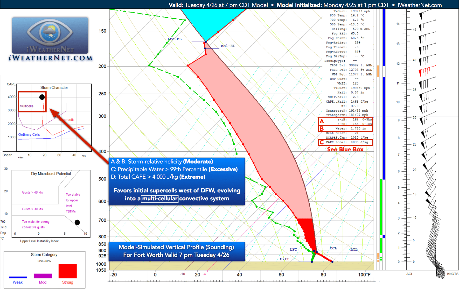
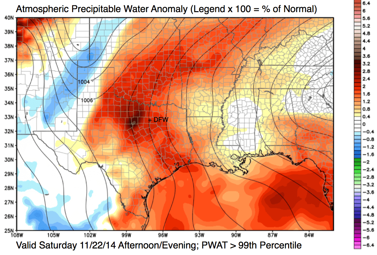
Flood forecasting: Precipitable water (PWAT) > 99th percentile is critical

April 30, 2019April 18, 2016 by Chris Robbins
Atmospheric precipitable water content anomaly, valid this afternoon/evening (11/22/14). To determine the percent of normal, multiply the legend by 100.

Global Wind 7-Day Satellite Loop Note: The purpose of this post is to share advanced forecasting techniques, not present formal research at this time.   Example Case: April 17-18, 2016 Heavy Rain Event in North Texas ◙  I wanted to show some of the 48-hour rainfall amounts as of 7:00 am CDT April 18, 2016 (officially … Read more

DFW: Severe thunderstorms possible Tuesday Evening 4/26

December 18, 2016April 25, 2016 by Chris Robbins
Forecast sounding for Fort Worth valid 7pm CDT April 26, 2016

I typically do not share model data because they can be very complex. I do want to show one of the state-of-the-art programs that I use in my operations to analyze model-simulated soundings. The models do not automatically compute these data; the additional software turns the raw output into meaningful information. At least one of … Read more

Dry line convergence & thunderstorm squall line formation

December 18, 2016April 26, 2016 by Chris Robbins

This phenomenon is NOT unusual, but it doesn’t always happen.  Today, the dry line and the resulting squall-line were perfectly aligned.  The data presented a teaching moment that I couldn’t pass up.  At the end of the animation, I zoom in so you can see the wind barbs pointing toward the dry line. The air … Read more

2025 © iWeatherNet.com