May 2015 was an exhausting month for forecasters in Oklahoma and Texas. One storm system after another brought enormous rainfall and significant flooding to many areas. I will try to post some dynamics/thermodynamics analyses or a general recap of each individual storm system in a future addendum to this post. For now, I wanted to share some statistics and precipitation graphics.
Statistics:
● Total Rainfall: 16.96″ | Normal: 4.90″
● 12.06″ Above Normal | 346% of Normal | 246% Above Normal
● Third-Wettest Month of ALL-Time
● Wettest May Ever Recorded for DFW
● Period of Weather Records at DFW is 126 years, 9 months and 24 days (9-1-1898 to Present)
Shattered Previous May Record by 24%
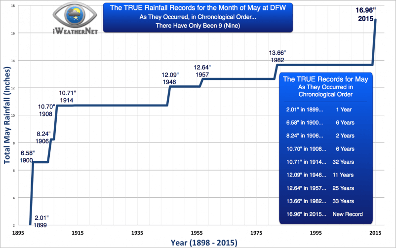
I crunched the numbers and isolated all of the former rainfall records for the month of May. This is a different way of viewing the rainfall data. Sure, we can rank all of the years and see that there are many, many “greatest amounts”, but there are only 9 (nine) true former #1 title holders. By definition of a record, they occur in chronological order from the time that record keeping began. Obviously, the first year of record keeping is a record in-and-of itself. It didn’t take a lot to break that record the next year. Nevertheless, here are the records (previous #1 spots).
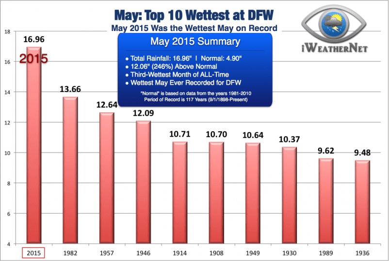
Now, we take a look at the “top wettest” in the dataset. Some of these weren’t ever #1 records; rather, I’ve taken all of the monthly rainfall data for every May since records began and I sorted them. There are no considerations of chronology.
Tabular Data: Top-50 Largest Rainfall Amounts Ever Recorded in the Month of May at DFW
Bear in mind from the discussion above… A ranking of the largest precipitation amounts does not mean these were ever “records” by definition. A “record” exists for a period of time because its absolute value is greater than any other data point prior to it in the chronological data set. Alternatively, a sorting of all data points from highest to lowest gives us “top 10 lists” or “top 20 lists,” and so on.
| Rank | Year | Rain Amount |
|---|---|---|
| 1 | 2015 | 16.96 |
| 2 | 1982 | 13.66 |
| 3 | 1957 | 12.64 |
| 4 | 1946 | 12.09 |
| 5 | 1914 | 10.71 |
| 6 | 1908 | 10.70 |
| 7 | 1949 | 10.64 |
| 8 | 1930 | 10.37 |
| 9 | 1989 | 9.62 |
| 10 | 1936 | 9.48 |
| 11 | 1935 | 9.15 |
| 12 | 1965 | 8.97 |
| 13 | 1920 | 8.56 |
| 14 | 2007 | 8.34 |
| 15 | 1906 | 8.24 |
| 16 | 1925 | 8.11 |
| 17 | 1978 | 8.01 |
| 18 | 2011 | 7.95 |
| 19 | 1943 | 7.83 |
| 20 | 1995 | 7.50 |
| 21 | 1990 | 7.16 |
| 22 | 1940 | 7.15 |
| 23 | 1969 | 7.12 |
| 24 | 1991 | 6.97 |
| 25 | 1992 | 6.93 |
| 26 | 1999 | 6.91 |
| 27 | 1975 | 6.88 |
| 28 | 1955 | 6.58 |
| 29 | 1900 | 6.58 |
| 30 | 1907 | 6.53 |
| 31 | 1944 | 6.42 |
| 32 | 1981 | 6.24 |
| 33 | 1950 | 6.16 |
| 34 | 1976 | 6.03 |
| 35 | 1932 | 6.03 |
| 36 | 1968 | 6.02 |
| 37 | 1974 | 6.00 |
| 38 | 1987 | 5.95 |
| 39 | 1979 | 5.90 |
| 40 | 1983 | 5.83 |
| 41 | 1929 | 5.83 |
| 42 | 1994 | 5.80 |
| 43 | 1910 | 5.76 |
| 44 | 2001 | 5.58 |
| 45 | 1986 | 5.52 |
| 46 | 1905 | 5.45 |
| 47 | 2002 | 5.40 |
| 48 | 2004 | 4.73 |
| 49 | 1933 | 4.67 |
| 50 | 1951 | 4.60 |
DFW’s 3rd-Wettest Month of ALL-TIME
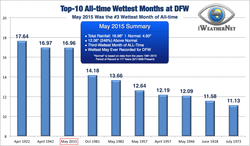
In addition to scoring the wettest May on record, it was also the third-wettest month of all-time. Note the difference in this particular statistic: “of all time” means of any month (January through December) dating back 117 years. We missed tying the #2 spot by a mere 0.01″ (one-hundredth of an inch); two-hundredths would have placed May 2015 as the 2nd-wettest of all-time.
We only needed another 0.69″ to break into the #1 spot; alas, we didn’t make it. Weather records can’t be fudged, not even a few hundredths of an inch; so after nearly drowning in water during the month of May, we must settle for #3. Yes I admit, there was a part of me that wanted a single thunderstorm to pass right over the rain gauge at DFW Airport (where no one lives), just so we could set an all-time record.
Other Graphics from North Texas and the Nation
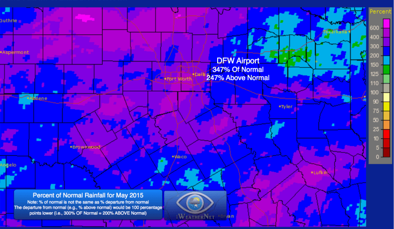
It’s important to remember that DFW is just one point, representative of Dallas/Fort Worth. It’s useful to use a specific location for consistency when gauging how the weather in one year compares to that of another, especially over the long term. Of course we all know that the weather varies spatially, and that is most true when it comes to mesoscale events (for example, thunderstorms). During May, we saw a number of mesoscale events in North Texas; specifically, we saw quite a few long-duration (training) thunderstorm events. Thunderstorms consistently developed within an atmosphere characterized by extreme moisture content (atmospheric precipitable water content exceeding the 99th percentile for May on many days) and they were producing rainfall rates in excess of 2 inches per hour at times. On some days, the thunderstorms would “train” repeatedly over the same areas for many hours. All tolled, some areas received well over 20 inches of rain.

Here is an interesting perspective — the percent of normal. The percent of normal is not the same as “percent above/below normal”. The latter would be the percent OF normal, less 100%. For example, if your rainfall is 100% of normal, that means your departure from normal is 0%. Similarly, the values shown on the map below are “of normal”. So if you see 500% of normal rainfall at your location for the month of May, that would be 400% above normal. Many people are confused by those subtle differences in wording, but they have statistical significance.
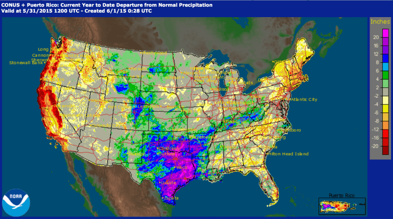
This map shows the departure from normal (in inches) year-to-date (January 1 through May 31)
