Cold-air damming (CAD), often called “the wedge” in the Southeast, is an interesting meteorological feature that can result in tricky forecasts for meteorologists. Topography plays a major role in CAD events, and you need a mountainous range for this feature to develop. While CAD can occur in the Rockies, it is predominant east of the Appalachian Mountains. How does CAD form, and why is it a tricky meteorological feature to nail down for meteorologists? You will find out that human forecasters can forecast these events better than most atmospheric models. Ultimately, accurate prediction of CAD comes down to a thorough understanding of the dynamics and physical processes that trigger them, climatology, and a working knowledge of how the numerical models operate.

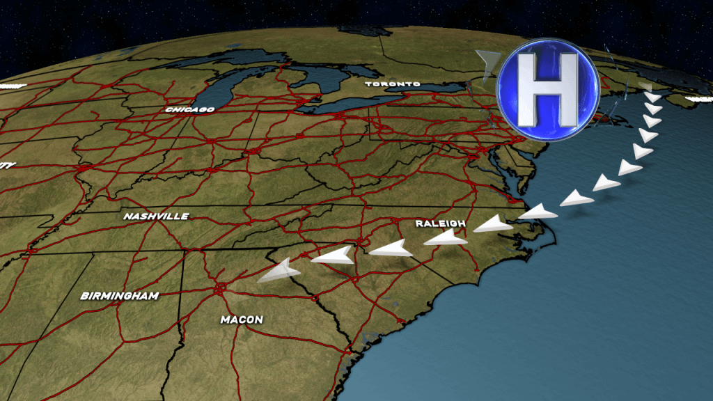
Cold-air damming occurs when cold air becomes entrenched against the windward side of a mountain range. Across the Appalachian Mountains, this shallow layer of cool air forms on the eastern side of the mountains and propagates to the southwest as ridging builds across the area. High pressure off the Northeast or near Nova Scotia brings a northeasterly surface wind that allows cooler (and drier) air to advect southwestward. This feature is very shallow, and only occurs at the surface to around 925 millibars (hPa). CAD is identified using observations of surface wind directions, temperatures, higher surface pressures, and dew points. Usually when CAD events form, drier air filters across the region and results in higher barometric pressures. If you look higher than about 925 mb, it typically becomes more difficult to detect since temperatures increase with height above the CAD layer. CAD can result in freezing rain/ice events in the winter across eastern Alabama, Georgia, South Carolina, and North Carolina.
CAD can be an extremely complicated feature in the winter months. CAD can affect precipitation types depending on the strength of the feature. For most cases, CAD events are notorious for creating ice storms in parts of the Southeast United States. Moisture from the Gulf of Mexico “overrides” the shallow layer of cold air at the surface. The warm air aloft and cool air at the surface enhances low level clouds. When rain falls into the shallow, dry layer of cold air at the surface, temperatures begin to drop via evaporative cooling. The drier the airmass, the lower the temperature can drop. For this reason, meteorologists are always on guard for the potential of freezing rain when the airmass is extremely dry. Sometimes the best way to gauge whether or not a location will drop at or below freezing is by monitoring the wet-bulb temperature. The wet-bulb temperature is the temperature a parcel of air would have if it were cooled to saturation (100% relative humidity) by the evaporation of water into it.

The Challenges of Forecasting CAD
Our weather models have improved significantly over the past ten years. While they will always have issues during small-scale events, they usually have a difficult time determining the following:
- The southern extent of where the wedge forms
- The intensity of the cold air damming event
- The duration of the event
Most of the time, cold air damming will affect North Carolina, South Carolina, and spread towards the southwest into Georgia, Alabama, and some extreme cases, as far south as the Florida Peninsula. How far will the shallow, cold air travel? In most cases, the numerical prediction models will show a warm front or area of low pressure bringing in warmer temperatures and moisture over the shallow layer of cool air. Models tend to force the warm front further north and at a speed faster than what actually verifies in most cases. The only way the wedge will erode quickly is if strong, synoptic-scale forcing pushes it out of the area.
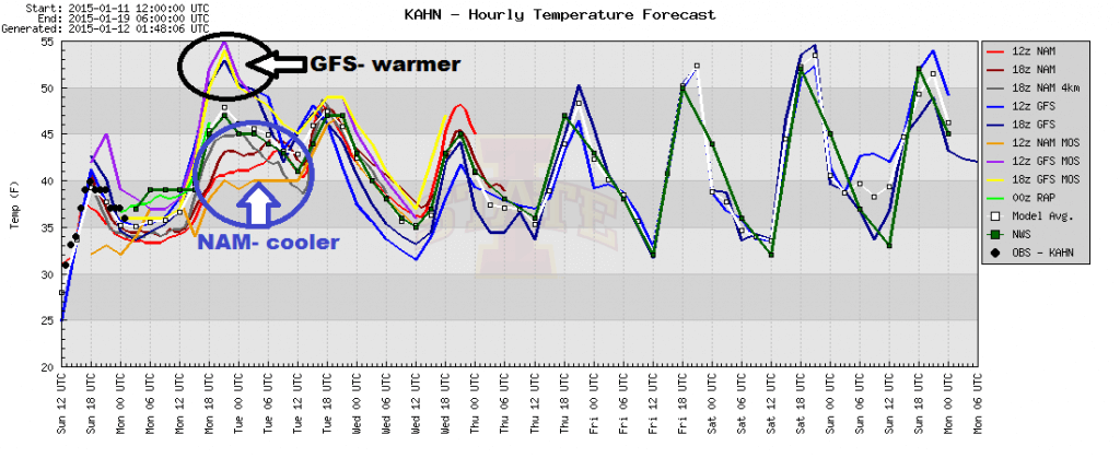
Models have a tendency to also underestimate the cool, dry air at the surface. Models might indicate temperatures in the upper 40s all day, but in real-life scenarios, highs might only verify in the upper 30s. When moisture falls into dry air, temperatures have a tendency to drop. Evaporative cooling from precipitation falling through the dry air within the CAD layer acts to reinforce (strengthen) the cold-air damming. Model Output Statistics (MOS) products can sometimes show temperature differences of 10 to 20 degrees in some CAD situations. Over the past couple of years, I have noticed that the GFS is getting better at depicting this feature. These improvements are likely due to enhancements and resolution upgrades to the GFS model in recent years.
Influence of the Wedge on Thunderstorms
CAD events can also mitigate or even prevent severe weather. Sometimes the outer edge of the wedge can interact with the warmer temperatures and southerly flow. Helicity and bulk shear values have a tendency to increase, particularly at the periphery of the wedge where the temperature gradient is strongest. Sometimes brief spin-up tornadoes can develop if there is sufficient forcing for thunderstorm formation. As those thunderstorms move north and/or east, further into the firmly entrenched cold-air damming area (more stable air), they tend to weaken.
Oftentimes, thunderstorms approaching from Alabama tend to dissipate as they encounter the relatively stable airmass within the CAD region. This phenomenon has been reported anecdotally by many longtime residents of northern Georgia. Many people cite the mountains to the west as the reason that thunderstorms “never make it across the state line”; however, the mountains to the west are only indirectly tied to thunderstorm dissipation. The tendency for thunderstorms to dissipate as they move into northern Georgia is linked directly to the climatological placement of the wedge, which rarely extends any further west than the higher terrain of eastern Alabama.
Thunderstorms can dissipate for other reasons also. For example, the simple issue of poor timing is one reason; if thunderstorms happen to be moving through eastern Alabama during peak afternoon heating, then cross into Georgia after sunset, the rapid atmospheric stabilization that occurs with the loss of daytime heating will often cause thunderstorms to dissipate (in the absence of large-scale forcing that might allow thunderstorms to persist into the night). In other cases, the large-scale storm track may be unfavorable, for example a southwest to northeast storm track over Alabama may send the forcing for thunderstorms into Tennessee, completely bypassing northern Georgia (this happens quite often). These latter two scenarios are a function of storm track, timing, and luck. Nevertheless, the presence of cold-air damming is likely the predominant cause of thunderstorm dissipation as observed by residents for generations.
Influence of Damming on Freezing Rain Formation
Although cold-air damming can occur year-round, they occur most frequently during the cold season. They are notorious for causing forecasting headaches among meteorologists when precipitation is involved. If the air is cold enough or if the air is sufficiently dry (i.e., characterized by subfreezing wet-bulb temperatures indicating the potential for significant evaporative cooling), winter precipitation may occur. Given the very shallow nature of the wedge, and when winter precipitation occurs (i.e., not just a “cold rain”), the most common precipitation type is freezing rain (see the conditional relative frequency map below).
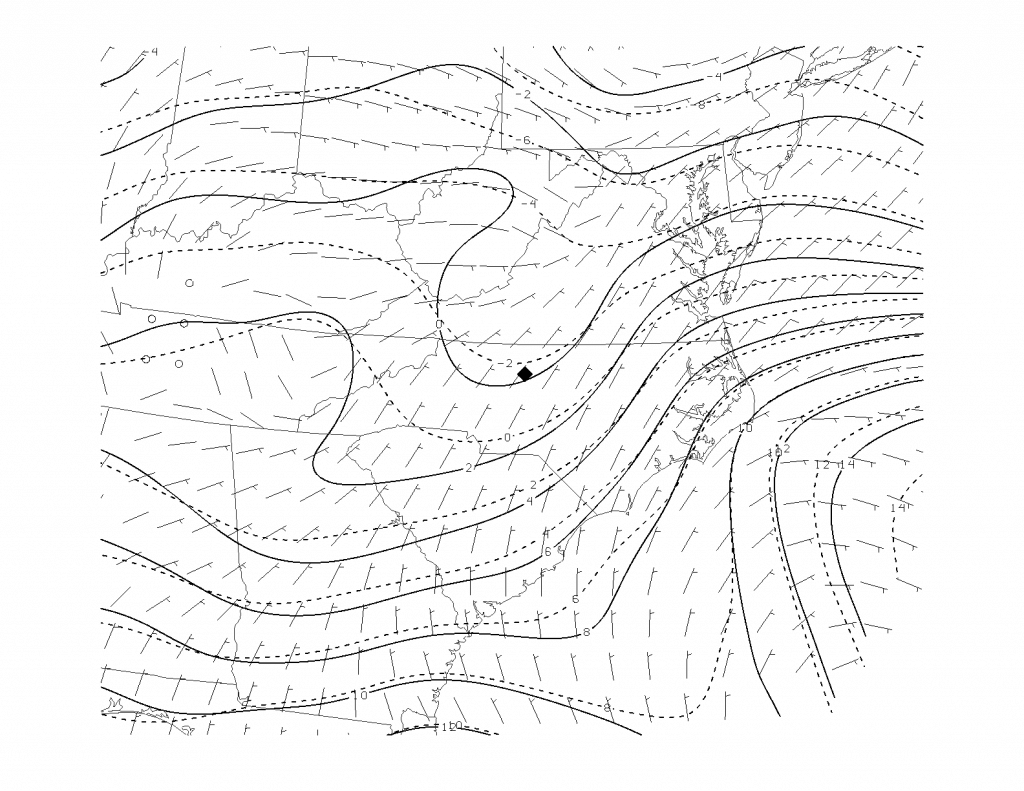
The following images show some basic statistics and the average synoptic environments associated with freezing rain during CAD events. These are from the research of Chris Robbins (see citation in the image captions).


Evolution of Temperatures During a Cold-Air Damming Event
The following animated image shows the development of a CAD event in February of 2014. This is *not* a forecast. It is intended to show how cold air advects southwestward into Georgia as a wedge develops/intensifies.

Summary/Overview
Cold-air damming events can occur at any time of the year, but are more common in the fall and winter months. It is a shallow layer of cold/dry air at the surface owing to northeasterly winds along the eastern slopes of the Appalachian Mountains. CAD events can help prevent severe weather, but it can also be responsible for freezing rain and ice storms in parts of North Carolina, South Carolina, and Georgia.
