Storm chasing is an emotional roller coaster. From operational field missions, to university research, and to the hobbyist and/or nature explorer, storm chasing consists of several thousand miles of driving for sometimes only an hour of action. Each Spring, scientists, meteorologists, hobbyists, and explorers, venture out to the Great Plains to seek some of the atmosphere’s most fascinating storms on Earth. These thunderstorms are called supercells, and a supercell is a thunderstorm that rotates.

A typical chase day, as they are called, begins with choosing your target area. Depending on the complexity of the severe weather set up, forecasting a target can take upwards of an hour or two. Careful analysis of realtime data, such as visible satellite imagery, surface observations, and the morning upper air data, aids greatly in choosing your area of interest. Sometimes, high resolution models such as the HRRR (High Resolution Rapid Refresh model) and RUC (Rapid Update Cycle model) in the morning can also help in pin pointing a potential location. But, they must be used for face value as forecast models are guidance and do not exactly indicate what will happen.
During the week of May 21st to May 26th, 2016, we traveled over 4,000 miles across Kansas and Oklahoma to seek out some of the atmosphere’s best performances. Storm chasing is very nomadic, and some of the annual operational field missions can easily log over 20,000 miles in a single chase season. Some towns that we come across are ghost towns, with perhaps a house or two. Other towns may only have a single gas station or a single place for food. So, the diet of a storm chaser is not always the greatest due to limit options. Usually, it is a good idea to pack a variety of snacks for your chase. During one of our chases, we even brought along a freshly cut pineapple which made for a great refreshment on a very hot day.
With the widespread use of multimedia and social media platforms today, some may think that you can essentially “get in your car, and go and see a tornado.” That is not accurate, as the Great Plains cover thousands of square miles of land. While a tornado may occur near a populated area and footage is captured, the chances of driving to a storm and actually seeing a tornado are very small. Tornadoes are in fact rare, despite the near consistent rate at which photographs and videos are broadcasted on to the mainstream media. But remember, that is due to the majority of the population having access to technology that transmits information realtime.
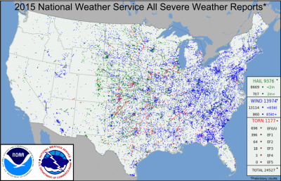
There are millions of thunderstorms on Earth each year, and only about 100,000 thunderstorms occur in the United States annually. Roughly 10%, or 10,000, of those storms are actually severe each year. And of those ~10,000 severe thunderstorms annually, only about 1,000 produce tornadoes annually in the United States according to U.S. severe thunderstorm and tornado databases. So from a statistical perspective, the chances are indeed low to see one of the most violent forces on Earth.

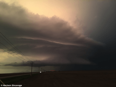
After looking at the morning data analyses, the sometimes several hour journey to the target area commences. In most cases, travel is done days before and/or overnight to reach a target area on time, as it can be several hundred miles away. Most of the time we arrive at our target area early, but sometimes storms can initiate early and there are times we show up late, or even as the storms begin to collapse. If you do arrive to your area of interest early, it can sometimes feel like an eternity for storms to initiate. This can be a combination of many things, such as having the adrenaline for the chase day, arriving early to the target, and/or conditions still have not come together for the genesis of thunderstorms. While chasing the Leoti, Kansas, supercell on Saturday, May 21st, 2016, we waited nearly three hours for supercells to initiate. However, after the cap was finally able to erode, we were treated to some of the most photogenic storm structure of the year.

Not all chases end up with success. The atmosphere does not always perform due to a variety of possibilities, such as a very strong cap that keeps air parcels from rising freely, to “overturned” air from early morning thunderstorms that stabilize the atmosphere. Sometimes, storm chasing turns into clear air chasing. This happened to our team on Wednesday, May 25th, 2016, as we headed east towards El Dorado, Kansas, just to the east of Wichita. A healthy updraft developed, and there was a distinct anvil at one point. However, the warm, moist inflow to the storm was undercut by its cool outflow and the storm collapsed on itself. Luckily this time, we were only 30 minutes away from home base in Wichita, Kansas.
Last year on May 23rd, 2015, we drove over 1,000 miles round trip into eastern Colorado. Parameters were looking favorable for supercells that day; however, there was no capping inversion and storms towered very early in the afternoon. Thereafter, storms could not organize, and they eventually gusted out into a non-severe broken line of thunderstorms. It made for a very long drive back to our home base in Wichita, Kansas.

Whether or not the atmosphere performs, and no matter what your missions and/or goal(s) are, storm chasing is an emotional ride itself. From the stress of forecasting the correct target area, to getting into position to collect invaluable datasets and/or to document the storm, to the thousands of miles of driving, it can take its toll. It can be quite exhausting, especially if one is not used to hours upon hours of driving. However, storm chasing is not all about seeing the tornadoes. In fact, it is far from it.
As mentioned, only a handful of supercells produce tornadoes. Witnessing the incredible structure of a supercell and its mesocyclone is just as rewarding as seeing a tornado, if not more rewarding. Nothing is more gratifying than forecasting a target area accurately and having the atmospheric ingredients come together to produce a picturesque storm in open fields. From the perspective of a meteorology student, when you can visually witness what is taught in the classroom, there is no better way to learn. More can be learned from the atmosphere in a few storm chases than what can be taught in an entire semester.
