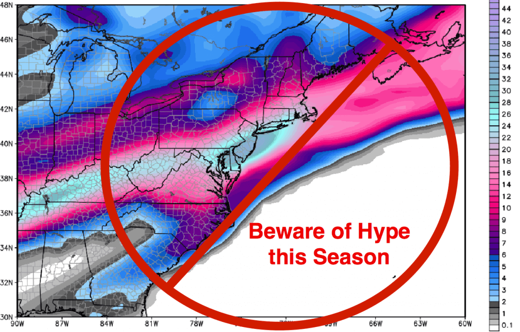
It’s that time of year… Winter. The season when those unrealistic snow and ice accumulation maps, for an unlikely event 10 days into the future, that often go viral on social media. So, I wanted to briefly discuss the nature of internet weather hype and how you can learn to recognize it. As the National Weather Service says, “Beware of the share!”
Seasonal Snowfall Hoaxes Posted Months Before Winter
I’ve seen these as early as August making false claims about the winter that lies ahead. Seasonal forecasting is a legitimate and evolving area of atmospheric prediction. Professional meteorologists with specialization in long-range forecasting attempt to predict the prevailing pattern for upcoming seasons. These forecasts are based on an enormous amount of data that are analyzed using complex statistical methods. However, click-hungry webmasters will also generate scary graphics with viral intent so that they will get thousands of clicks to their websites (and those clicks often convert to revenue if they have advertising all over their website). So, check the source before you share.

In the sections below, I go into more detail about the more common types of misinformation that we see during the winter months. These differ from seasonal hoaxes in that they attempt to spread hype about a “possible” event up to two weeks away.
Viral Snowfall Maps, Weather Hype, and Wish-Casting
We see them every winter: those “snowpocalyptic” screenshots depicting enormous snowfall accumulations 8 to 16 days into the future, usually taken from one model, and often for a region that is climatologically unfavored (for example, the Southeast). If you see anything like this in your news feed this winter, please know that it is *not* a forecast; it is merely a screenshot of a model that someone took without doing any deep-layer thermodynamic analyses. In most cases, these screenshots are created by someone who is “wish-casting” or with viral intent (for the purpose of generating likes/shares). Nine times out of 10, the model that hinted at those enormous snowfall amounts 10 days in advance will do a complete reversal on future operational model runs.

Flip-Flopping Models and Model Consistency
The atmospheric numerical prediction models “flip-flop” (change solutions) like crazy beyond 7 days, and we meteorologists understand this. We are continuously analyzing the various atmospheric oscillations, the global ocean/atmosphere teleconnections, and working to ensure that the models are ingesting good data for their simulations. We analyze the model simulations for many days before predicting snow, watching for both intramodel consistency (run-to-run within the same model) and intermodel consistency (consistency among all of the operational models). I studied winter storm dynamics, ice microphysics, and winter precipitation climatology in graduate school. I’ve published papers on the subject, and I’ve been a professional forecaster for two decades. Forecasting requires more than a mere computer boot up and a quick glance at the crude snow accumulation output. Rather, a good winter precipitation forecast requires hours of data analyses and inter/intramodel comparison, an understanding of ice microphysics, experience, and good old pattern recognition.
Weather enthusiasts often rely on the publicly accessible Global Forecast System model (GFS) which has become a household name thanks to social media. We professional forecasters use nearly a dozen models, each with varying temporal and spacial resolution, biases, and specialization (for example, tropical models, synoptic models, mesoscale/convective models, etc.). We watch for trends within and between the models; a real meteorologist doesn’t fire up the computer, see a ridiculous snowfall solution, and post it to the internet declaring “biggest blizzard in 25 years”; no sir, we wait until the next full model suite and odds are, the solutions will change. This is learned through experience and rigorous training, and those sharing the ridiculous images from untrained sources may not know that they emanate from young’uns playing weatherman.
Consideration of Local & Regional Winter-Weather Climatology
We also consider the snow/winter-precipitation climatology for the region of concern. To accomplish this, a forecaster will factor in the statistical probability of a significant winter weather event occurring at a particular location during a certain time of year. For example, in the Southeast, we understand that significant winter weather events are exceedingly rare during the month of December. Therefore, an exciting model forecast for heavy snow in Alabama or Georgia 10-days in advance in mid-December will be tempered by the unfavorable snow climatology for this area. Odds are, the model will flip-flop with future runs as it ingests more and better data. Taking climatology into account helps to produce a more accurate forecast and reduces the number of false alarms (crying wolf).
Accurate Snow Forecasting: The Models Do Not Equal a Forecast
Atmospheric prediction is a complex, physical science, and it is NOT a race to see who can “call it first.” Rather, a good and well-trained meteorologist will absorb/analyze the data for many days and make the call (if necessary) as confidence increases. Atmospheric prediction involves MUCH more than just regurgitating the models, particularly when it comes to winter-weather forecasting.
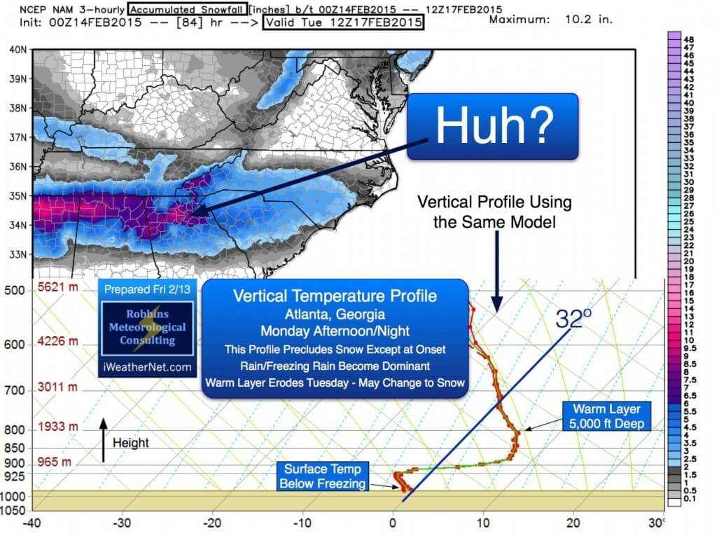
Enormous computational resources are required to accurately assess (integrate) the vertical thermodynamic and water vapor profiles algorithmically. Model-generated snow is often inaccurate, and the winter-precipitation algorithms often mishandle the various mid/upper-level warm layers and other mitigating thermodynamic/microphysical factors. Accurate weather forecasting requires a deep understanding of the NWP models and their limitations, forecaster experience, pattern recognition, a thorough understanding of atmospheric dynamics, physics, and thermodynamics, and of course, patience.
Remember, just because someone posted an image of model-simulated snow/ice days before anyone else does not mean they “called it first.” Calling it first is irrelevant among respected members of the meteorological community (and the public). What’s important is that the forecaster go through the rigorous forecast process and “call it” accurately when the time is right — and call it with confidence and with specifics. Every meteorologist in the country sees that first model, especially if the snow algorithm is painting snow accumulations. It takes no skill whatsoever to snap a quick screenshot and post it online with a dramatic headline.
The following image is an example of a snow algorithm poorly resolving a very deep warm layer aloft. Same model, same time period. RAOB sounding point is West Atlanta (8″ snow depicted by the algorithm).

The difference between a model-caster and a good forecaster lies with the forecaster’s ability to catch the events that the snow algorithms do not (and for the right reasons, meteorologically speaking). I’ve seen numerous cases wherein a snow algorithm was converting all of the model-generated precipitation to snow using a 10:1 ratio. However, during my data analyses, I was able to identify mitigating thermodynamic and microphysical factors aloft and determine that the snow to liquid ratio used by the model was inappropriate or that freezing rain/sleet would be the prevailing precipitation type(s). In those events, as expected, screenshots of model-simulated snow accumulation of up to two feet spread like wildfire online. The reality was a just couple of inches of snow and an inch or two of sleet/freezing rain.
I Love Snow… But…
Just like other weather geeks out there, I get excited at the slightest chance of snow here in the South. When I see a model hinting at a possible winter weather event 10 days out, the little kid in me gets excited and I await the next model run like the proverbial kid in a candy store. However, as a professional meteorologist who specialized in winter storm dynamics and prediction, I know better than to forecast snow based on that first inkling from a single model run. I also know from nearly two decades of forecasting experience that the long-range model guidance will most likely change solutions on future operational runs. I certainly wouldn’t post those screenshots on the internet for my followers to get concerned about. Again, meteorology is a rigorous mathematical/physical science and forecasting the weather is a complex process. I will analyze the models (and the data going into them) for many days before mentioning snow/ice, particularly in climatologically unfavored regions, such as the Deep South.
Reliable Sources of Weather Information
In the digital age, there are countless sources for weather information available to you at your fingertips. My advice is to follow someone that you trust, particularly someone who avoids the hyped headlines and has a good forecasting track record. There is a time and place for hype, and that’s when and where an imminent danger exists. This post is NOT meant to be demeaning toward weather enthusiasts or weather forecasters who may not hold a degree in meteorology; to the contrary, we appreciate their drive, passion, and dedication to this profession. Most are very good at what they do because it is their passion. The National Weather Service and professional private-sector organizations try to work closely with everyone connected to the industry (by passion and/or degree), to ensure that the public receives consistent and reliable information in a timely manner. Most of the weather enthusiasts that I know do an excellent job and take weather forecasting seriously. Quite literally, I can count on just one hand the number of untrustworthy/hype-based weather sources; and unfortunately, they seem to have the loudest voices.
Social Media: Beware of the Share
The following image was created by the National Weather Service in Norman, Oklahoma and offers some very good tips for sharing weather information online. A very important point that they note is that model simulations are not forecasts. Accurate weather forecasts require humans to interpret the data, using the atmospheric models as guidance. Sometimes the models are wrong, and a human meteorologist can make that determination using pattern recognition, their experience, and their knowledge of atmospheric science. Know your weather source, and let’s work together to share accurate and reliable information this winter.

