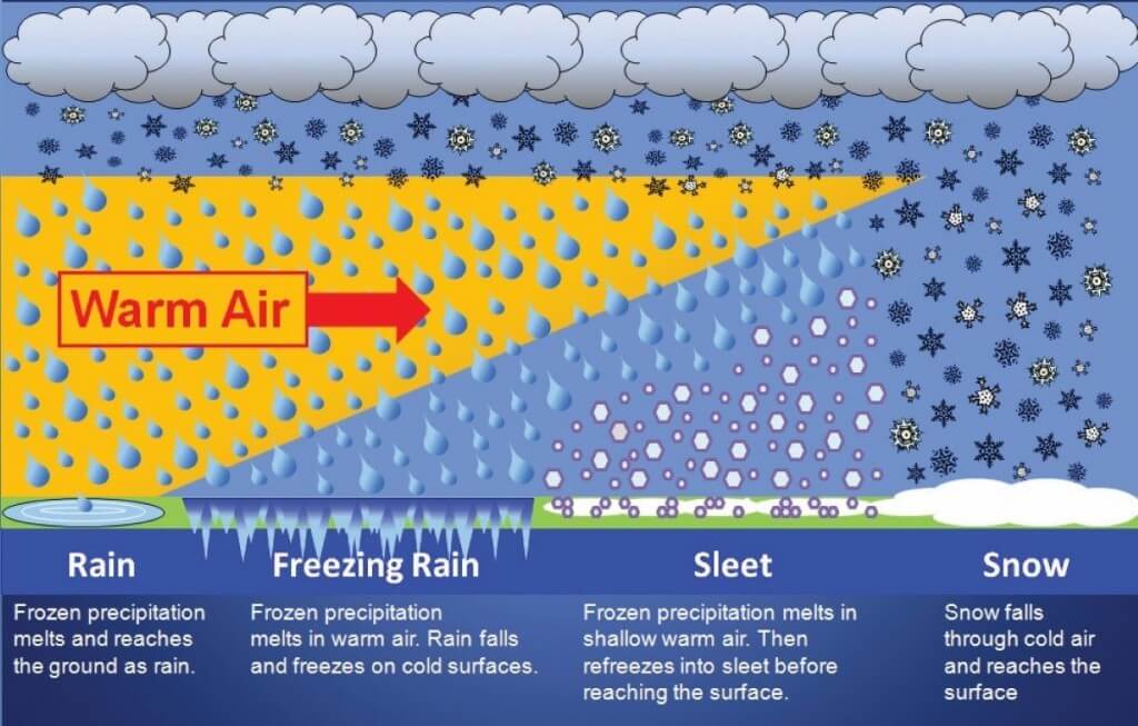
When it comes to winter weather, there is no shortage of advisory types. This page is devoted to the four main winter weather products: Winter Storm Watch, Winter Storm Warning, Winter Weather Advisory, and Ice Storm Warning. More specifically, I want to discuss the criteria used by the National Weather Service Office in Fort Worth, Texas (NWS-FWD) when issuing winter weather products for North Texas and what each of these alerts mean. The criteria vary from region to region, based on climatological susceptibility to winter weather. Some regions are more accustomed to winter weather and are better equipped to handle large amounts of winter precipitation. In those regions, higher criteria are used; likewise, areas that rarely see snow, such as the Southeast, have much lower thresholds.
✏️ Tip: The National Weather Service in Fort Worth is the official source for all advisories, watches, and warnings for North Texas, including the Dallas/Fort Worth Metroplex. Be sure to bookmark their page: http://www.srh.noaa.gov/fwd, and follow them on Twitter and Facebook.

The Hierarchy of Winter Weather Products
I’m sometimes surprised that in the era of modern meteorology, people are still confused by watches and warnings. This is not only true for winter weather, but also for severe thunderstorms and tornadoes. I am frequently asked, “which is ‘worse’, a watch or a warning?” In all cases, a warning is “worse” than a watch. When I say “worse”, I mean the event is imminent or already occurring.
❄️The following is the hierarchy for winter weather products (alerts):
Winter Storm Watch < Winter Weather Advisory < Winter Storm Warning
In other words, both an “advisory” and a “warning” are upgrades to a watch. This means that an advisory is “worse” than a watch and a warning is “worse” than an advisory. They each have their own criteria which vary from region to region. However, I personally prefer to avoid the “worse than” mentality, because it is far more important to focus on the predicted impacts for your community. Suppose a half inch of freezing rain is predicted for the county to your south, but only a tenth of an inch of freezing rain is expected to glaze the roads in your town. What will be the impact of that amount of ice in your community, irrespective of the higher amounts predicted in the adjacent county?

So, when it comes to Advisories and Warnings, these are merely alert types. The details of those alerts are always available in text form directly from the National Weather Service. You can also use the interactive watch/warning/advisory display on iWeatherNet, which allows you to click any location and read the entire alert text. As you read the text, or as you listen to the forecast from your favorite meteorologist, focus on the impacts that the storm will have on your community.
✏️ Tip: Make sure you follow (and share information from) credible sources for weather information. Beware of winter-weather hype created by unreliable or untrained internet sources as hype created by “model-casters” tends to run rampant on social media.
As we learned during “snow jam 2014” in the Southeast in January of 2014, even one or two inches of snow can have an enormous impact, particularly in regions that are not well-equipped to handle snow or ice. With all of that said, let’s discuss the winter storm criteria used by the National Weather Service office in Fort Worth when issuing winter-weather alerts for North Texas.
Winter Storm Criteria for North Texas

Winter Storm Watch
When a watch is issued, make sure to pay attention to the specific forecast for your community and the possible impacts. This is the time to plan ahead for the possibility of a significant winter weather event. As the event draws near, and forecaster confidence increases, the Watch may be upgraded to an Advisory or a Warning. A Watch is issued up to 48 hours in advance of an event when there is a 50% greater chance that one or more of the following will occur (but not imminently):
- Heavy snow accumulating to 4 or more inches in a 12 hour period, or
- Heavy snow accumulating to 6 or more inches within a 24 hour period; or
- Sleet accumulations of 1/2 inch or more; or
- Freezing rain accretion to 1/4 inch or more; or
- Any combination of these events
Winter Weather Advisory
An Advisory means that winter weather is imminent, but the expected amounts do not rise to “Warning” criteria. An Advisory an upgrade to a watch (in some rapidly developing situations, an Advisory may be issued when a “Watch” wasn’t previously in effect). An Advisory is also a downgrade from a Warning (if a Warning was previously in effect for your area). A Winter Weather Advisory is typically issued up to 36 hours before an event if there is an 80 percent chance or greater that winter precipitation will develop, but the predicted accumulations do not rise to warning criteria. Note: If freezing rain is expected to be the predominant precipitation type, but the anticipated amounts do not meet “Ice Storm Warning” criteria, a Freezing Rain Advisory may be issued in lieu of a Winter Weather Advisory, at forecaster discretion. An example would be light freezing rain that could cause a very thin glaze, but not cause tree damage or widespread power outages.
Winter Storm Warning
A Winter Storm Warning means that significant winter weather is imminent or already occurring. These are typically issued 12 to 24 hours ahead of an event that has an 80 percent chance or greater of meeting one or more of the following conditions:
- Heavy snow accumulating to 4 or more inches in a 12 hour period, or
- Heavy snow accumulating to 6 or more inches within a 24 hour period; or
- Sleet accumulations of 1/2 inch or more; or
- Freezing rain accretion to 1/4 inch or more; or
- Any combination of these events
Ice Storm Warning
An Ice Storm Warning is simply a more specific form of a Winter Storm Warning, when freezing rain is expected to be the predominant precipitation type and may cause significant travel disruptions, tree damage, and power outages. These are typically issued 12 to 24 hours in advance of an event that has an 80% or greater chance of freezing rain accumulating to 1/4 inch or more on all exposed surfaces, including trees and power lines. is issued up to 36 hours before an event if there is an 80% chance or greater that freezing rain will accumulate to ¼ inch or more. It doesn’t take a lot of freezing rain or freezing drizzle to create hazardous driving conditions, even if an Ice Storm Warning is not issued. For freezing rain events with less than 1/4 inch expected, a Freezing Rain Advisory may be issued. Again, focus on the predicted impacts for your community rather than the amounts for adjacent areas.
Final Thoughts
Again, this only covers the four main precipitation-based winter-weather alerts. I also touched on Freezing Rain Advisories, which can be used in lieu of Winter Weather Advisories when freezing rain is the primary precipitation type. There are many other types of alerts, such as Blizzard Warnings, Heavy Snow Warnings, and Lake-effect Snow Warnings. Clearly, since these are “warnings”, they are “worse” than an advisory or a watch. They, just like the “Ice Storm Warning” discussed above, are more specific forms of the generic Winter Storm Warning.
If you have any questions or have suggestions on ways that I can clarify the information provided, please feel free to contact me using the contact links in the top navigation.
-Chris Robbins, Meteorologist, M.S.
